Posted in Անգլերենի անհատական նախագիծ, Անգլերենի նախագծեր

Vayots Dzor Region

Presentation

Վայոց ձորի մարզ - Վիքիպեդիա՝ ազատ հանրագիտարան

Vayots Dzor is located in the southeastern part of Armenia. It borders on Nakhichevan in the west and the Kalbajar District in the east. Vayots Dzor is surrounded by high mountains and mountain chains that make natural barriers for its neighboring areas. The region has rich flora and fauna.

The Province of Vayots Dzor has the least number of population in Armenia. The three important towns are Yeghegnadzor, Jermuk, and Vayk. The people here are very conservative: they celebrate nearly all the religious and traditional festivals. The most famous celebration is the harvest festival which takes place every year on the second Sunday of October.

Yeghegnadzor is the historic and cultural centre of Vayots Dzor. It is one of the oldest residences in Armenia which is situated on the right bank of the River Arpa. The city’s name was first mentioned in the 7th century. For some period of time it was known as Mikoyan; in honour of Great Armenian politician Anastas Mikoyan.

Historical Sights of Vayots Dzor

Noravank Monastery

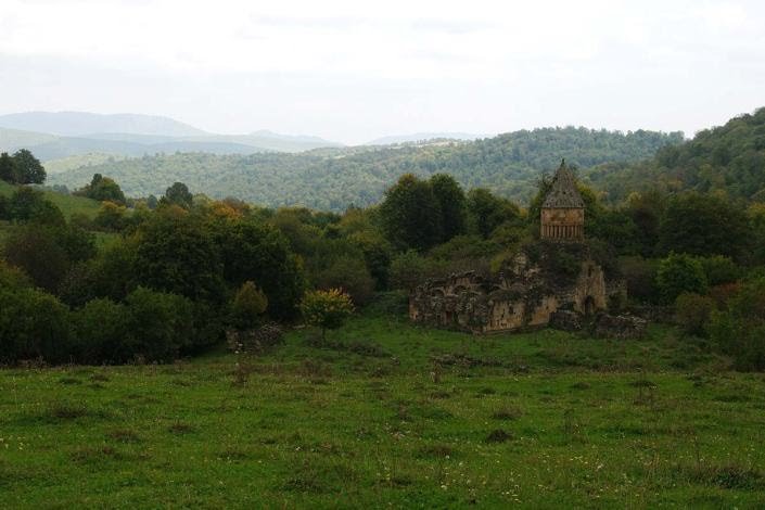
The most popular place in Vayots Dzor is the Noravank Monastery of the 13th century. The monastic complex includes the church of St. Karapet, St. Grigor chapel and the church of St. Astvatsatsin (Holy Mother of God).

The monastery is best known for its two-storey Surb Astvatsatsin Church which was completed in 1339. The monastery is a masterpiece created by the talented sculptor and miniaturist Momik. Noravank is the last work of the master, who died the same year Noravank was completed and was buried at the church. 

In 2002 the Monastery of Noravank was included in the UNESCO World Heritage List. 

Jermuk Waterfall

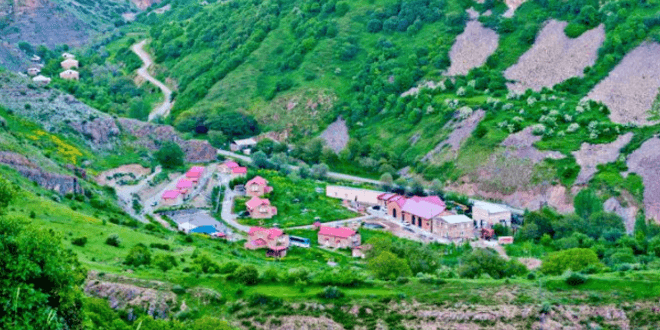
The second important town in Vayots Dzor is Jermuk — the most famous and popular sanatorium in Armenia. It is surrounded by mountains and thick forests. Jermuk is rich with fresh and mineral water springs. There is also an underground geyser used for drinking and taking baths. It cures various diseases and neurological disorders. 

The waterfall of Jermuk is a must-see attraction of Vayots Dzor. It is the second-largest waterfall in Armenia (70 meters). Together with the picturesque surroundings, the waterfall makes an impressive view. 

Kechut Reservoir

3.5 km to the South from Jermuk, on the river Arpa, Kechut Water Reservoir is located. It was built in 1981 to regulate the water level of Lake Sevan. 

The population of Vayots Dzor Region

According to the census of 2011, only 52 324 people live in the province of Vayots Dzor: 99.74 % Armenians, 0.15% Russians, 0.04 % Ukrainians.

Yeghegnadzor

Yeghegnadzor

Yeghegnadzor is the administrative centre of Vayots Dzor Region. It is situated in the southeastern part of Armenia on the banks of the Srkghonk River, a tributary of the Arpa River. The city is 123 km south of the capital Yerevan, at the height of 1194 meters above sea level. The climate is mild with snowy winters and warm summers.

History of Yeghegnadzor

The name of the city consists of two Armenian words: «yegheg» meaning «cane» and «dzor» meaning «valley», so the name means «valley of canes». It is one of the oldest residences of Armenia. The city was first mentioned in the 5th century. It belonged to the Vayots Dzor canton of Syunik which was the 9th province of Great Armenia.

Many churches, monastic complexes, bridges and caravanserais were built in the city during the 10th-13th centuries.

In 1747, when Eastern Armenia was still under Iranian rule, the city became part of Nakhichevan Khanate and was known as Keshishkend. In 1935 it was renamed Mikoyan after the politician and Bolshevik leader Anastas Mikoyan. In 1956 the town got its present name.

Sights of Yeghegnadzor

Yeghegnadzor is the historical and cultural centre of Vayots Dzor. Many ancient churches are located here. The most popular place in the town is the Noravank Monastery of the 13th-14th centuries. Zorats St. Astvatsatsin Church (Holy Mother of God) is another work of art to see in Yeghegnadzor. 

The Cathedral of the Holy Mother of God of the 12th century (also known as St. Sarkis) serves as the seat of the Vayots Dzor Diocese of the Armenian Apostolic Church. 

Not far from the town of Yeghegnadzor is Spitakavor Monastery of the Holy Mother of God which was built in 1321. It is a remarkable monastery isolated in nature with the stunning surrounding scenery. The remains of the Armenian national hero and military leader Garegin Nzhdeh were secretly buried in the yard of Spitakavor Monastery in the 1980s. He had died in a Soviet prison in 1955.

The historic University of Gladzor of the 13th century was located at the outskirts of Yeghegnadzor. It was a great centre of learning which operated until 1340. 

In 1984 on the 700th anniversary of Gladzor University, the Historic-Cultural Preserve-Museum of Gladzor University was established in the historic church of Surb Hakob (St. Jacob) in Vernashen village.

There is also an archaeological museum in the town, as well as an art school, a sports school and a musical academy.

The popular harvest festival takes place in Yeghegnadzor every year on the second Sunday of October. 

Վայոց ձորը գտնվում է Հայաստանի հարավ-արևելյան մասում։ Արևմուտքում սահմանակից է Նախիջևանին, արևելքից՝ Քալբաջարի շրջանին։ Վայոց ձորը շրջապատված է բարձր լեռներով և լեռնաշղթաներով, որոնք բնական պատնեշներ են ստեղծում նրա հարևան տարածքների համար։ Տարածաշրջանն ունի հարուստ բուսական և կենդանական աշխարհ։

Հայաստանում ամենաքիչ բնակչությունն ունի Վայոց ձորի մարզը։ Երեք կարևոր քաղաքներն են  Եղեգնաձորը ,  Ջերմուկը և  Վայքը ։ Այստեղ մարդիկ շատ պահպանողական են. նրանք նշում են գրեթե բոլոր կրոնական և ավանդական տոները: Ամենահայտնի տոնակատարությունը բերքի տոնն է, որը տեղի է ունենում ամեն տարի հոկտեմբերի երկրորդ կիրակի օրը:

Եղեգնաձորը Վայոց ձորի պատմամշակութային կենտրոնն է։ Այն Հայաստանի հնագույն բնակավայրերից է, որը գտնվում է Արփա գետի աջ ափին։ Քաղաքի անունը առաջին անգամ հիշատակվել է 7-րդ դարում։ Որոշ ժամանակ այն հայտնի էր որպես Միկոյան; ի պատիվ հայ մեծ քաղաքական գործիչ Անաստաս Միկոյանի.

Վայոց ձորի պատմական տեսարժան վայրեր

Նորավանք վանք

Վայոց ձորի ամենասիրված վայրը   13-րդ դարի Նորավանք վանքն է։ Վանական համալիրը ներառում է Սուրբ Կարապետ եկեղեցին, Սուրբ Գրիգոր մատուռը և Սուրբ Աստվածածին եկեղեցին։

Վանքը առավել հայտնի է իր երկհարկանի Սուրբ Աստվածածին եկեղեցով, որն ավարտվել է 1339 թվականին: Վանքը գլուխգործոց է, որը ստեղծել է տաղանդավոր քանդակագործ և մանրանկարիչ  Մոմիկը : Նորավանքը վարպետի վերջին գործն է, ով վախճանվել է նույն թվականին Նորավանքի ավարտին և թաղվել եկեղեցում։ 

2002 թվականին Նորավանք վանքը ներառվել է ՅՈՒՆԵՍԿՕ-ի համաշխարհային ժառանգության ցանկում։ 

Ջերմուկի ջրվեժ

Վայոց ձորի երկրորդ կարևոր քաղաքը  Ջերմուկն է  ՝ Հայաստանի ամենահայտնի և սիրված առողջարանը։ Շրջապատված է լեռներով և թավուտ անտառներով։ Ջերմուկը հարուստ է քաղցրահամ և հանքային ջրերի աղբյուրներով։ Կա նաև ստորգետնյա գեյզեր, որն օգտագործվում է խմելու և լոգանք ընդունելու համար։ Այն բուժում է տարբեր հիվանդություններ և նյարդաբանական խանգարումներ։ 

Ջերմուկի ջրվեժը Վայոց ձորի տեսարժան վայրն է։ Այն Հայաստանի մեծությամբ երկրորդ ջրվեժն է (70 մետր): Գեղատեսիլ շրջապատի հետ մեկտեղ ջրվեժը տպավորիչ տեսարան է բացում։ 

Կեչուտի ջրամբար

Ջերմուկից 3,5 կմ դեպի հարավ՝ Արփա գետի վրա, գտնվում է Կեչուտի ջրամբարը։ Այն կառուցվել է 1981 թվականին՝ Սեւանա լճի ջրի մակարդակը կարգավորելու նպատակով։ 

Վայոց ձորի մարզի բնակչությունը

2011 թվականի մարդահամարի տվյալներով Վայոց ձորի մարզում ապրում է ընդամենը 52 324 մարդ՝ 99,74 % հայեր, 0,15 % ռուսներ, 0,04 % ուկրաինացիներ։

Եղեգնաձոր

Եղեգնաձոր

Եղեգնաձորը Վայոց ձորի մարզի վարչական կենտրոնն է   ։ Գտնվում է Հայաստանի հարավ-արևելյան մասում՝ Արփա գետի վտակ Սրկղոնք գետի ափին։ Քաղաքը գտնվում է մայրաքաղաք  Երևանից 123 կմ հարավ , ծովի մակարդակից 1194 մ բարձրության վրա։ Կլիման մեղմ է՝ ձյունառատ ձմեռներով և տաք ամառներով։

Եղեգնաձորի պատմություն

Քաղաքի անունը կազմված է հայերեն երկու բառից՝ «եղեգ» նշանակում է «եղեգ» և «ձոր»՝ «հովիտ», ուստի անունը նշանակում է «ձեռնափայտի հովիտ»։ Այն Հայաստանի հնագույն բնակավայրերից է։ Քաղաքն առաջին անգամ հիշատակվել է 5-րդ դարում։ Պատկանել է Սյունիքի Վայոց ձորի կանտոնին,  որը  Մեծ Հայքի 9-րդ նահանգն էր։

10-13-րդ դարերում քաղաքում կառուցվել են բազմաթիվ եկեղեցիներ, վանական համալիրներ, կամուրջներ, քարավանատներ։

1747 թվականին, երբ Արևելյան Հայաստանը դեռ իրանական տիրապետության տակ էր, քաղաքը մտավ Նախիջևանի խանության մեջ և հայտնի էր Քեշիշքենդ անունով։ 1935 թվականին այն վերանվանվել է Միկոյան՝ քաղաքական գործիչ և բոլշևիկների առաջնորդ Անաստաս Միկոյանի անունով։ 1956 թվականին քաղաքը ստացել է իր ներկայիս անվանումը։

Եղեգնաձորի տեսարժան վայրերը

Եղեգնաձորը Վայոց ձորի պատմամշակութային կենտրոնն է։ Այստեղ են գտնվում բազմաթիվ հնագույն եկեղեցիներ։ Քաղաքի ամենասիրված վայրը  13-14-րդ դարերի  Նորավանք վանքն է։ Զորաց Սուրբ Աստվածածին եկեղեցին (Սուրբ Աստվածածին) արվեստի ևս մեկ գործ է Եղեգնաձորում: 

12-րդ դարի Սուրբ Աստվածածին տաճարը (հայտնի է նաև Սուրբ Սարգիս անունով) Հայ Առաքելական եկեղեցու Վայոց ձորի թեմի նստավայրն է։ 

Եղեգնաձոր քաղաքից ոչ հեռու գտնվում է Սուրբ Աստվածածնի Սպիտակավոր վանքը, որը կառուցվել է 1321 թվականին: Այն բնության մեջ մեկուսի ուշագրավ վանք է՝ շրջապատող ապշեցուցիչ տեսարաններով: Հայոց ազգային հերոս և զորավար Գարեգին Նժդեհի աճյունը գաղտնի ամփոփվել է Սպիտակավոր վանքի բակում 1980-ականներին։ Նա մահացել էր խորհրդային բանտում 1955թ.

Եղեգնաձորի ծայրամասում էր գտնվում 13-րդ դարի Գլաձորի պատմական համալսարանը։ Այն եղել է մեծ ուսումնական կենտրոն, որը գործել է մինչև 1340 թվականը։ 

1984 թվականին Գլաձոր համալսարանի հիմնադրման 700-ամյակին Վերնաշեն գյուղի Սուրբ Հակոբ (Սուրբ Հակոբ) պատմական եկեղեցում ստեղծվել է Գլաձորի համալսարանի պատմամշակութային արգելոց-թանգարանը։

Քաղաքում կա նաև հնագիտական ​​թանգարան, ինչպես նաև արվեստի դպրոց, մարզադպրոց և երաժշտական ​​ակադեմիա։

Ամեն տարի հոկտեմբերի երկրորդ կիրակի օրը Եղեգնաձորում տեղի է ունենում բերքի հանրաճանաչ տոնը։ 

Posted in Անգլերենի նախագծեր

Սյունիքի լեռնագրությունը

Զանգեզուրի լեռնաշղթա

Զանգեզուրի լեռնաշղթա կամ Զանգեզուրի լեռներ, այն գտնվում է Սյունիքի մարզում, Հայաստանի հարավ-արևելքում։ Ձգվում է միջօրեականի ուղղությամբ՝ Վարդենիսի և Արևելյան Սևանի լեռնաշղթաների հանգուցվելու կետից (Քեթի լեռ) մինչև Արաքս գետի Մեղրու կիրճը։ Երկարությունը շուրջ 130 կմ։ Առավելագույն բարձրությունը Կապուտջուղ լեռն է, որի բարձրությունը 3904 մ։

Zangezur mountain range or Zangezur mountains, it is located in Syunik Marz, in the southeast of Armenia. It stretches in the direction of the meridian from the meeting point of the Vardenis and Eastern Sevan mountain ranges (Mount Keti) to the Meghri Gorge of the Araks River. The length is about 130 km. The maximum height is Kaputjugh mountain, the height of which is 3904 m.

Կապուտջուղ լեռ

Կապուտջուղ լեռնագագաթը գտնվում է Սյունիքի մարզի և Նախիջևանի սահմանագլխին՝ Քաջարանց գյուղից 9 կմ արևմուտք: Բարձրությունը՝ 3906 մ։ Հարաբերական համեմատաբար փոքր բարձրության շնորհիվ, բարձրությունը շրջապատի նկատմամբ այդքան էլ լավ արտահայտված չէ, սակայն լեռը ՀՀ տարածքում բարձրությամբ երկրորդն է՝ Արագածից հետո: Լեռան լանջերը զառիթափ են, պատված ալպյան և մերձալպյան բուսականությամբ: Գագաթային մասերում պահպանվում են ձնաբծեր:

Kaputjugh mountain peak is located at the border of Syunik marz and Nakhijevan, 9 km west of Kajarants village. Height: 3906 m. Due to its relatively small height, the height is not so well expressed in relation to the surroundings, but the mountain is the second highest in the territory of RA, after Aragats. The mountain slopes are steep, covered with alpine and sub-alpine vegetation. Spots of snow persist in the summit parts.

Իշխանասար

Մեծ Իշխանասար լեռն Իշխանասար լեռնազանգվածի ամենաբարձր կետն է: Գտնվում է Սյունիքի և Արցախի սահմանագլխին, Նորավան գյուղից 9 կմ հյուսիս-արևելք: Բարձրությունը՝ 3549 մ: Լեռան հյուսիսային լանջից է սկիզբ առնում Որոտանի ձախ՝ Նորավան վտակը, հյուսիս-արևմուտք-ից՝ Նորավան գետի ձախ վտակ Մեծձորը, իսկ հվ-արմ. լանջից՝ Որոտանի ձախ վտակ Վաղատինը, հարավ-ից՝ Շամբ գետը: Լեռն ունի հրաբխային ծագում. լանջերը զառիթափ են, մասնատված կիրճերով և ձորակներով:

Մեծ Իշխանասար լեռան հյուսիսում առանձնանում է Փոքր Իշխանասար լեռը: Հյուսիս արևմուտքում Իշխանասարը թամքոցով միանում է Ծղուկ լեռնազանգվածին: Արևելյան լանջին է սառցադաշտային ծագման Սև լիճը՝ 2666 մ բարձրության վրա: Լիճն ունի 1,6 կմ երկարություն և 1,2 կմ լայնություն: Մակերեսը՝ մոտ 2 քառ. կմ, առավելագույն խորությունը 7,5 մ: Համարյա շրջանաձև է:

Great Ishkhanasar mountain is the highest point of the Ishkhanasar massif. It is located at the border of Syunik and Artsakh, 9 km northeast of Noravan village. Height: 3549 m. The Noravan tributary to the left of Vorotan starts from the northern slope of the mountain, the Metsdzor, the left tributary of the Noravan River, from the northwest. from the slope, Vaghatin, the left tributary of Vorotan, from the south, Shamb river. The mountain has a volcanic origin. the slopes are steep, dissected by ravines and ravines.

In the north of the Great Ishkhanasar Mountain stands out the Little Ishkhanasar Mountain. In the northwest, Ishkhanasar joins the Tsguk massif through a gorge. On the eastern slope is the Black Lake of glacial origin at an altitude of 2666 m. The lake is 1.6 km long and 1.2 km wide. Area: about 2 sq. km, the maximum depth is 7.5 m. It is almost circular.

Ուխտասար

Ուխտասարը լեռ է ՀՀ Սյունիքի բարձրավանդակի կենտրոնական հատվածում, որտեղ 1968 թվականին հայտնաբերվել է ժայռապատկերներով հարուստ հնավայր։ Այն գտնվում է 3000-3300 մ ծովի մակերևույթից բարձրության վրա:
Ուխտասարի ժայռապատկերները ներկայանում են սև ու մոխրագույն հրաբխային ծագում ունեցող քարերի վրա քարե գործիքներով արված փորագրությունների տեսքով։ Դրանց մեծ մասը համարվում են հուշագրեր` նվիրված ննջեցյալների կյանքին ու հերոսական պատմություններին։ Հարուստ են բույսերի, ծաղիկների և կենդանիների, ինչպես նաև մարդկային ու երկրաչափական պատկերներով արված փորագրությունները։

Ukhtasar is a mountain in the central part of the Syunik Plateau of RA, where an ancient site rich in rock paintings was discovered in 1968. It is located at an altitude of 3000-3300 m above sea level.
Ukhtasar petroglyphs appear in the form of carvings made with stone tools on black and gray volcanic stones. Most of them are considered to be memoirs dedicated to the lives and heroic stories of those who fell asleep. There are rich carvings of plants, flowers and animals, as well as human and geometric figures.

Ծղուկ

Հանգած հրաբխային լեռնազանգված Սյունիքի բարձրավանդակում՝ ՀՀ Սյունիքի մարզում: Ունի 3581 մ բարձրություն, գագաթին կա ջրածածկ ոչ մեծ խառնարան, զառիթափ ու կտրտված լանջեր, որոնք ցածրանում են դեպի լեռնազանգվածը եզերող սարավանդները։ Շրջակայքում կան անտառներ, վերին մասում՝ ծանծաղ լճեր։

Ծղուկի գագաթից դեպի հյուսիս բացվում է հիանալի տեսարան դեպի Սյունիքի բարձրավանդակի ամենաբարձր կետը՝ Թրասարը (3594 մ): Դեպի հյուսիս-արևելք երևում է սեղանասարը և մի գեղեցիկ լիճ:

Located on the Syunik plateau, Syunik Marz, RA. It has a height of 3581 m, on the top there is a small crater covered with water, steep and cut slopes, which descend towards the mountains bordering the mountain range. There are forests in the vicinity, shallow lakes in the upper part.

From the top of Tskhuk, a wonderful view of the highest point of the Syunik Plateau, Trasar (3594 m), opens to the north. To the north-east you can see the table and a beautiful lake.

Թրասար

Թրասար լեռնագագաթը գտնվում է Սառնակունք գյուղից 16 կմ դեպի հյուսիս–արևելք Սյունիքի բարձրավանդակում՝ Սյունիքի մարզի և Արցախի սահմանագլխին: : Ծղուկի լեռների ամենաբարձր գագաթն է: Բարձրությունը 3594 մ է:

The Trasar peak is located 16 km to the north-east of Sarnakunk village in Syunik plateau, at the border of Syunik region and Artsakh. It is the highest peak of Tsguk mountains. The height is 3594 m.

Խուստուփ

Լեռնազանգվածը գտնվում է Սյունիքի մարզում, Կապան քաղաքից 9 կմ հարավ-արևմտյան: Խուստուփի հարավ-արևելյան լանջից են սկիզբ առնում Ողջի գետի աջ՝ Գեղանուշ և Վաչագան վտակները, իսկ հարավ-արևմտյան. լանջից՝ Ծավ գետի ձախ վտակ Շիշկերտը: Լեռն ունի ալպյան մարգագետինների հարուստ բուսածածկույթ, հյուսիս-արևելյան. լանջերն անտառապատ են:

The mountain range is located in Syunik region, 9 km southwest of Kapan city. From the south-eastern slope of Khustup, the right tributaries of the Voghji river, the Geghanus and Vachagan tributaries, and the south-western from the slope: Shishkert, the left tributary of the Tsav River. The mountain has a rich vegetation of alpine meadows, north-east. the slopes are wooded.

• Կատար

Կատար լեռնազանգվածը գտնվում է Սյունիքի մարզում, Վերին Գիրաթաղ գյուղից 2,3 կմ հյուսիս-արևելք։ Ունի 3012մ. բարձրություն։ Լեռան հարավ-արևելյան լանջից է սկիզբ առնում Ողջի գետի ձախ վտակը՝ Շղարշիկը։

The Katar massif is located in Syunik region, 2.3 km northeast of Verin Giratagh village. It has 3012m. height. The left tributary of Voghji river, Shgharshik, originates from the south-eastern slope of the mountain.

Posted in Անգլերենի նախագծեր

Cultural turizm

Presentation

Մշակութային-ճանաչողական զբոսաշրջությունը կատարվում է այս կամ այն տեղանքի բնությունը, պատմամշակութային հուշարձաններն այցելելու, տեղի բնակչության կենցաղին և ավանդույթներին, գիտության բնագավառում կատարված ձեռքբերումներին, արվեստի ազգային ձևերին, արհեստներին ծանոթանալու նպատակով: «Թանգարան բաց երկնքի տակ» – հենց այսպես են Հայաստանն անվանում: Մեր երկիրն, իրոք, հարուստ է գեղատեսիլ վայրերով պատմական և մշակութային նշանակության հուշարձաններով: Հայաստանը զարդարում են ավելի քան չորս հազար ինքնատիպ հուշարձանները, դրանցից է Սևանը լիճը Հայաստանում Գեղարքունիքի մարզում: Այն ամենախոշոր լիճն է Կովկասում, ինչպես նաև աշխարհի քաղցրահամ ամենաբարձր մեծ լճերից է: Գտնվում է ծովի մակերևույթից 1900 մ բարձրության վրա, մակերեսը 1240 կմ2 է, խորությունը հասնում է 80 մ – ի: Սևանից սկիզբ է առնում Հրազդան գետը: Հրազդան և Սևան գետերի ջուրն օգտագործվում է Սևան կասկադի հիդրոէլեկտրակայանի (հէկ) համար: Սևանի ջրի մակարդակը բարձրացնելու նպատակով կառուցվել է 48 կիլոմետր երկարությամբ Արփա-Սևան թունելը Արփա գետի ջրերը լիճ տեղափոխելու համար: Իսկ 1978 թ. ստեղծվել է Սևանի ազգային պարկը: Հնում Սևանա լիճը հայտնի է եղել Գեղամա ծով, Գեղարքունյաց ծով կամ Լիխնիտիս անուններով։ 5-րդ դար պատմիչ Մովսես Խորենացու մոտ վկայութուն է պահպանվել Սևանա լիճի հին Գեղամա ծովի անվան ծագման պատմության վերաբերյալ: Այսպիսովխոսելով Հայկ Նահապետի հետնորդների մասին պատմիչը գրում է, որ այն այդպես է կոչվել Գեղամ անունով մի այրի պատվին: Վերջինս գաղթել է հարավից Արմավիրից, գնացել հյուսիս և, հրապուրվելով գեղատեսիլ բնությամբ, բնակություն է հաստատել Սևանա լճի ափին, որը և նրա անունով Գեղամա է կոչվել (իսկ մարզը Գեղարքունիք): Մինչ վերջերս Սևան բառը ստուգաբանում էին հետևյալ կերպ – Սև և Վանք – այստեղ հրաբխային տուֆից կառուցված Սևանավանքի պատերի գույնից ելնելով: Բայց ափից գտնված քարի վրայի սեպագիր արձանագրության վերծանման համաձայն Սևան անունը գալիս է ուրարտական Սունիա – լիճ ձևից: Դուք երբևէ տեսել եք քաղաք կամ գյուղ, ուր կան հարյուրավոր տներ,և ոչ մի բնակիչ «մեռած» քաղաք, վայր, որտեղ 50 տարի առաջ դեռ կար բնակչություն: Գորիս քաղաքից 8 կմ դեպի արևելք ընկած հեռավորության վրա ծովի մակարդակից 1580 մ բարձրության վրա խորը ձորի լանջերին ուշագրավ ժայռերի գրկում է գտնվում Հայաստանի հետաքրքրական վայրերից մեկը Հին Խնձորեսկը: Անբացատրելի է այն տպավորությունը, երբ նայում ես Խնձորեսկի անմատչելի ժայռերի վրա գտնվող քարայրներին: Մարդիկ, դարեր շարունակ ապրելով աշխարհից ասես կտրված այս անկյունում ժայռերի մեջ, բնության գրկում, մշտապես պաշտպանվել են թշնամիներից, սովից, տապից, անձրևից և գիշատիչներից: Հետաքրիր է, որ մարդիկ ապրել են այս քարայրներում մինչև 1958 թվականը, երբ Հայաստանն արդեն զարգացած արդյունաբերական երկիր էր: Գյուղի տները մեծ մասամբ ժայռերի մեջ են փորված: Բնակելի շատ տներ կառուցվել են գետնից 20-30 մ բարձրության վրա մեկը մյուսի վրա, երբ առաջինի տանիքը հիմք է հանդիսացել երկրորդի համար: Այստեղ գործել են եկեղեցի և դպրոց. Դա խոսում է մշակութային և հոգևոր կյանքի առկայության մասին: Ձորի մեջ է գտնվում նաև 18-րդ դարի առաջին քառորդում թուրքական և պարսկական նվաճողների դեմ պայքարող մեծ զորավար Մխիթար Սպարապետի գերեզմանը: Հին խնձորեսկը պատմական հուշարձան է, որը գտնվում է պետական պաշտպանության տակ:

Cultural-cognitive tourism is carried out in order to visit the nature, historical and cultural monuments of this or that place, to get acquainted with the lifestyle and traditions of the local population, achievements in the field of science, national forms of art, crafts. «Museum under the open sky» — that’s what they call Armenia. Our country is really rich in beautiful places with monuments of historical and cultural significance. Armenia is decorated with more than four thousand original monuments, among them is Lake Sevan in Gegharkunik region of Armenia. It is the largest lake in the Caucasus, as well as one of the highest large freshwater lakes in the world. It is located at an altitude of 1900 m above sea level, the surface is 1240 km2, the depth reaches 80 m. Hrazdan river originates from Sevan. The water of the Hrazdan and Sevan rivers is used for the Sevan Cascade Hydroelectric Power Plant (HEP). In order to raise the water level of Sevan, the 48-kilometer Arpa-Sevan tunnel was built to transfer the waters of the Arpa River to the lake. And in 1978 Sevan National Park was created. In ancient times, Lake Sevan was known as Geghama Sea, Gegharkunyats Sea or Lichnitis. The testimony of the 5th century historian Movses Khorenatsi has been preserved regarding the history of the origin of the old name of Lake Sevan, Geghama Sea. Thus, speaking about Hayk Nahapet’s descendants, the historian writes that it was named after a widow named Gegham. The latter migrated from the south, from Armavir, went to the north and, attracted by the beautiful nature, settled on the shore of Lake Sevan, which was named Geghama after him (and the region is Gegharkunik). Until recently, the word Sevan was etymologically interpreted as follows — Sev and Vank — here based on the color of the walls of Sevanavank, built of volcanic tuff. But according to the decoding of the cuneiform inscription on the stone found on the shore, the name Sevan comes from the Urartian Sunia — lake. Have you ever seen a town or village where there are hundreds of houses and no inhabitants — a «dead» town, a place where there was still a population 50 years ago? At a distance of 8 km to the east of the city of Goris, at an altitude of 1580 m above sea level, on the slopes of a deep gorge, one of the interesting places of Armenia is located — Old Khndzoresk. The impression when you look at the caves on the inaccessible rocks of Khndzoresk is inexplicable. People, living for centuries in this corner as if cut off from the world, in the rocks, in the lap of nature, have always protected themselves from enemies, hunger, heat, rain and predators. It is interesting that people lived in these caves until 1958, when Armenia was already a developed industrial country. Village houses are mostly dug into the rocks. Many residential houses were built 20-30 m above the ground, one on top of the other, with the roof of the first being the foundation for the second. A church and a school functioned here. It speaks of the presence of cultural and spiritual life. The grave of Mkhitar Sparapet, a great general who fought against the Turkish and Persian conquerors in the first quarter of the 18th century, is also located in the valley. The old apple tree is a historical monument under state protection.

Posted in Անգլերենի նախագծեր

I would like to be like

I want to be like my mother and sister, because they are a bright example of what a real Armenian woman should be. I always wonder how they manage to do everything on time. My sister is a bright example of a real Armenian woman. Let me tell him a little about. He is a programmer and writer. He is already the author of 2 books: «Mi bur arev» and «Hogu Ezerk». At the same time, she is respected by those around her, she is a good woman in the family, an exemplary daughter-in-law. She plays the piano very well, can make beautiful clothes, and cooks delicious food. My sister supports me in every matter, when I need help I turn to her.

Posted in Անգլերենի նախագծեր

Լոռու մարզի լեռնագրությունը

Presentation

Լոռու մարզը գտնվում է Հայաստանի Հանրապետության հյուսիսային մասում։ Քաղաքային բնակչության թվով թաղամասն առաջատարն է։ Զբաղեցնում է ՀՀ տարածքի մոտ 12%-ը՝ ներառյալ Սպիտակի, Ստեփանավանի, Տաշիրի, Թումանյանի, Գուգարքի տարածաշրջանները։ Մարզկենտրոնը Վանաձորն է։

Lori region is located in the northern part of the Republic of Armenia. The district is the leader in terms of urban population. It occupies about 12% of the territory of the Republic of Armenia, including Spitak, Stepanavan, Tashir, Tumanyan, Gugark regions. The regional center is Vanadzor.

Նրա տարածքով են ձգվում Ջավախքի, Բազումի, Փամբակի, Գուգարաց, Վիրահայոց, Հալաբի լեռնաշղթաները։ Հատկապես աչքի են ընկնում Փամբակի, Լորվա գոգավորությունները, Լորվա հովիտը։ Տարածաշրջանում ծովի մակարդակից ամենաբարձր կետը Ախլասար լեռան գագաթն է (3196 մ), ամենացածրը՝ Դեբեդ գետի ստորին հոսանքը (մոտ 375 մ)։ Սպիտակի լեռնանցքով (բարձրությունը՝ 2378 մ) կապված է Արագածոտնի մարզի հետ, Պուշկինի լեռնանցքով (բարձրությունը՝ 2038 մ) Լոռվա դաշտը Փամբակի ավազանի հետ։

The Javakhk, Bazum, Pambak, Gugarats, Virahayots, Halab mountain ranges stretch across its territory. The Pambak, Lorva depressions and the Lorva valley stand out in particular. The highest point above sea level in the region is the peak of Mount Achkasar (3,196 m), the lowest point is the lower reaches of the Debed River (about 375 m). Through the Spitak Pass (altitude 2378 m) it is connected with the Aragatsotn region, through the Pushkin Pass (altitude 2038 m) the Lori field with the Pambak basin.

Ուրասար լեռ

Ուրասար / Բազումի լեռներ

Ուրասար լեռը գտնվում է Լոռվա և Շիրակի մարզերի սահմանագլխին:  Բարձրությունը 2992 մետր է: Բազումի լեռների ամենաբարձր կետն է: Լեռան հվ-արմ. լանջից է սկիզբ առնում Չիչկան գետի ձախ՝ Ձորաշեն վտակը, իսկ հս.-արլ. Լանջին է գտնվում Պաղաղբյուրը: Ուրասարի լանջերը զառիթափ են, մասնատված և ծածկված ալպյան մարգագետիններով:

Վերելքը կարելի է սկսել ենք Շիրակի մարզի Ձորաշեն գյուղից: Գյուղից մինչև գագաթ հարաբերական բարձրությունը մոտ 1000 մետր է։

Mount Urasar is located at the border of Lorva and Shirak regions. The height is 2992 meters. It is the highest point of Bazumi mountains. The Dzorashen tributary of Chichkan River originates from the south-western slope of the mountain, and Paghaghbyur is located on the north-eastern slope. The slopes of Urasar are steep, fragmented and covered with alpine meadows.
The ascent can be started from Dzorashen village of Shirak region. The relative height from the village to the peak is about 1000 meters.

Աչքասար

Achkasar4.jpg

Աչքասար լեռը գտնվում է Լոռու մարզում՝  Սարագյուղից 6 կմ արևելք, Ջավախքի լեռնաշղթայի ամենաբարձր գագաթն է։ Ունի 3196 մ բարձրություն։ Անտրոպոգենի լավային կոն է՝ կազմված անդեզիտադացիտներից։ Լանջերը զառիթափ են և բարձր մասերում ծածկված են քարակարկառներով։

Akhlasar mountain is located in Lori marz, 6 km east of Saragyugh, it is the highest peak of the Javakhk mountain range. It has a height of 3196 m. It is an anthropogenic lava cone composed of andesita dacites. The slopes are steep and covered with boulders in the higher parts.

Թեժ լեռ

Թեժլեռ լեռնագագաթը գտնվում է Հայաստանի Լոռու և Կոտայքի մարզերի սահմանագլխին, Մարգահովիտ գյուղից 7 կմ հյուսիս-արևմուտք: Հանդիսանում է Փամբակի լեռնաշղթայի ամենաբարձր կետը և տեղակայված է լեռնաշղթայի կենտրոնական հատվածում։ Բարձրությունը՝ 3101 մ։ Ներժայթուք է՝ կազմված էոցենի հրաբխային ապարներից (նեֆելինային սիենիտներ, գրանիտներ)։ Լանջերը զառիթափ են, լանդշաֆտը՝ լեռնամարգագետնային։

Tezhler mountain peak is located at the border of Lori and Kotayk regions of Armenia, 7 km northwest of Margahovit village. It is the highest point of the Pambak mountain range and is located in the central part of the mountain range. Height: 3101 m. It is an eruption made of Eocene volcanic rocks (nepheline syenites, granites). The slopes are steep, the landscape is a mountain meadow.

Լալվար

Վիրահայոց լեռների արևելյան մասում է գտնվում Լալվար լեռնագագաթը: Հանդիսանում է լեռնաշղթայի ամենաբարձր կետը: Մասնատված է ճառագայթաձև տարածում ունեցող բազմաթիվ գետահովիտներով: Կատարային մասը հարթ է, տեղ-տեղ ալիքավոր: 2000-2200 մ բարձրությունների վրա կան քարափներ, ժայռեր ու աղբյուրներ: Լալվար լեռան լանջերը տարբերվում են միմյանցից, թե՛ մասնատվածությամբ, թե՛ անտառածածկ լինելով: Հս. և արմ. լանջերը ավելի քիչ մասնատված են և ավելի ատնառապատ քան հվ. և արլ. լանջերը: Գագաթային մասում` ինչպես ՀՀ-ի բոլոր բարձր լեռներին է բնորոշ, տարածվում են մերձալպյան և ալպյան բուսականությունը:

Հայաստանի ազգային պատկերասրահում են գտնվում մեծանուն նկարիչներ՝ Մարտիրոս Սարյանի և Փանոս Թերլեմեզյանի Լալվար լեռան տեսարանը ներկայացնող կտավները:

The Lalvar peak is located in the eastern part of the Armenian mountains. It is the highest point of the mountain range. It is divided by many river valleys with radial distribution. The Qatari part is flat, wavy in places. At 2000-2200 m altitude there are rocks, rocks and springs. The slopes of Lalwar mountain differ from each other, both in fragmentation and forest cover. Hs. and arm. the slopes are less fragmented and more wooded than hv. and arl. the slopes. In the top part, as is typical of all the high mountains of RA, sub-alpine and alpine vegetation spreads.

The National Gallery of Armenia houses the paintings of famous artists Martiros Saryan and Panos Terlemezyan depicting the view of Lalvar Mountain.

Դժարսար

Դժարսարը գտնվում է Քարինջ գյուղից 6,5 կմ հս.-արլ: Այստեղից են սկսում Սևորդյաց լեռները: Լեռան ստորին լանջերն անտառապատ են, իսկ ավելի բարձրադիր մասերում տարածված է մարգագետնային առատ բուսականությունը:

5000 դրամանոց թղթադրամներին պատկերված է Մարտիրոս Սարյանի «Քարինջ գյուղի կոլտնտեսությունը» կտավը: Կտավն արտացոլում է Լոռվա բնությունը: Քարինջ գյուղից այն կողմ Սևորդյաց լեռներն են:

Djarsar is located 6.5 km northeast of Karinj village. This is where the Sevordyats mountains begin. The lower slopes of the mountain are forested, and the higher parts have abundant meadow vegetation.

The 5,000-dram banknotes depict Martiros Saryan’s painting «Collective Economy of Karinj Village». The canvas reflects the nature of Lorva. Beyond the village of Karinj are the Sevordyats mountains.

Posted in Անգլերենի նախագծեր

ՓԱՌԱՆՁԵՄ

ՓԱՌԱՆՁԵՄ

Մեծ Հայքի Արշակունյաց թագավորության ամենահայտնի թագուհին Փառանձեմն է՝ Արշակ II-ի կինը:

Փառանձեմը ոչ միայն Մեծ Հայքի Արշակունյաց թագավորության ամենահայտնի թագուհին է, այլև մեր պատմության ամենաակնառու դեմքերից մեկը:

Նա Սյունաց նախարարական տոհմից էր՝ դուստրն Անդոկ /Անտիոք/ Սյունիի, որը IV դարի հայ իրականության ակնառու դեմքերից մեկն էր: Օրիորդ Փառանձեմը «շատ հռչակված էր իր գեղեցկությամբ և պարկեշտությամբ»: Նա ամուսնանում է Արշակ II արքայի եղբորորդի Գնել Արշակունու հետ, կազմում նրա հետ փոխադարձ սիրով ստեղծված ընտանիք:

Իշխանուհու բացառիկ գեղեցկությունն ու հմայքը բավականին արագ փոխեցին նրա կյանքի ընթացքը: Ըստ մատենագիրների՝ նրան սիրահարվում է Գնելի հորեղբորորդին՝ Տիրիթը, որն էլ դավեր է նյութում Գնելի դեմ: Նա կարողանում է թագավորին համոզել, թե Գնելը պատրաստվում է գրավել Մեծ Հայքի գահը, որն էլ պատճառ է դառնում, որ թագավորը հանձնարարի սպանել նրան:


The most famous queen of the Arshakun kingdom of Great Hayek is Parandzem, the wife of Arshak II.

Parandzem is not only the most famous queen of the Arshakunyat kingdom of Great Hayek, but also one of the most prominent figures in our history.

She was from the Senate ministerial lineage, the daughter of Andok /Antioch/Syuni, who was one of the outstanding figures of the Armenian reality of the 4th century. Miss Parandzem was «well-known for her beauty and decency.» She married Glen Arshak, the nephew of King Arshak II, forms a family with him created by mutual love.

The exceptional beauty and charm of the princess changed the course of his life quite quickly. According to the chroniclers, she falls in love with Gnel cousin, Tirith, who conspired against Gnel. He manages to convince the king that Gnel is going to seize the throne of Great Britain, which causes the king to order him killed.

Posted in Անգլերենի նախագծեր

The mountains of Tavush region

Presentacion

Տավուշի մարզի արևմտյան հատվածով է ձգվում Գուգարաց լեռները, հս․ հատվածով է ձգվում Պապաքարի լեռնրը,հվ, տարածվում է Ոսկեպարի լեռները, հվ․ գտնվում Մթնասարի լեռները, Իջևանի լեռները, արևելյան հատվածով ձգվում է Վարագի լեռները, Կենաց լեռները, Տավուշի լեռները Խնձորուտի լեռները, այս լեռներից էլ հարավ տարածվում է Միափորի լեռները, որի ամենաբարձր կետը Միափորն է։

The Gugarats Mountains stretch along the western part of Tavush Marz, the Papakar Mountains stretch along the northern part, the Voskepar Mountains stretch along the southern part, the Mtnasari Mountains, the Ijevan Mountains stretch along the southern part, the Varagi Mountains, Kenats Mountains, Tavush Mountains stretch along the eastern part, the Khndzorut Mountains, and south of these mountains. extends to the mountains of Miapor, the highest point of which is Miapor.

Gugarats Mountains

Գուգարաց լեռներ գտնվում է  Հայաստանի Լոռու և Տավուշի մարզերի սահմանագլխին, Դեբեդ և  Աղստև գետերի ջրբաժանը։ Ձգվում է Բովաքարի լեռների արևելյան եզրից դեպի հյուսիս՝ շուրջ 80 կմ։ Առավելագույն բարձրությունը Դժարսար լեռն է, որը ունի 2245 մ բարձրություն։ Միջին բարձրություն 2000 մ

Gugarats Mountains are located at the border of Lori and Tavush marzes of Armenia, the watershed of Debed and Aghstev rivers. It stretches from the eastern edge of the Bovakar mountains to the north, about 80 km. The maximum height is Dzharsar mountain, which has a height of 2245 m. Average height 2000 m.

Papakar mountains

Պապաքարի լեռներ, Հայաստանի Տավուշի մարզի, Վրաստանի և Ադրբեջանի սահմանագլխին։ Ձգվում է Դեբեդի հովտից մինչև Կուր և Խրամ գետերի միախառնման վայրը։ Երկարությունը 24 կմ է, միջին բարձրությունը՝ 600-1000 մ

Papakar mountains, Tavush region of Armenia, on the border of Georgia and Azerbaijan. It stretches from the valley of Debed to the confluence of the Kur and Khram rivers. The length is 24 km, the average height is 600-1000 m․

Mount Mtnsar

Մթնսար լեռը Գուգարաց լեռների հս-արլ. ճյուղավորությունն է: Ձգվում է Պաղակն լեռնագագաթից մինչև Ադրբեջանի տարածք: Երկարությունը` 38 կմ: Բարձր գագաթներից են Խատուտիկ լեռը՝ 1964 մ, Պայտաթափը՝ 1979 մ, Ճիլիսը՝ 1916 մ, Արածո լեռը՝ 1868 մ: 

Mount Mtnsar is north-eastern branch of Gugarats mountains. It starts from the mount Paghakn to the territory of Azerbaijan. The length is 38 km. It’s highest summits are: mount Khatutik – 1964 m, Paytatap – 1979 m, Chilis – 1916 m and Aratso – 1868 m.

Ijevan mountains

Իջևանի լեռները գտնվում են Տավուշի մարզում: Հանդիսանում են Գուգարաց լեռների հվ-արլ ճյուղավորությունը: Լեռնաշղթան սկսվում է Գուգարաց լեռների Բազեաքար գագաթից և հս-արլ ուղղությամբ ձգվում մինչև Աղստև և Սառնաջուր գետերի միախառնման վայրը: Երկարությունը՝ 32 կմ: Ջրբաժան է Սառնաջուր և Դեղինաղբյուր գետերի միջև: Լեռների հս-արլ. և հվ-արլ. լանջերն անտառապատ են: Ամենաբարձր կետը՝ Սառցապատ լեռն է (2532 մ) (Կայենի լեռներ):

Ijevan mountains are located in Tavush region and are considered to be the south-eastern branch of Gugarats mountains. Ijevan mountains start from Bazeakar peak of Gugarats mountains and stretches to north-east till the meeting point of Aghstev and Sarnadjur rivers. The length of the mountain range is 32 km․ The north-eastern and south-eastern slopes of the mountains are covered with forests. The highest point of Ijevan mountains is mount Sartsapat with the height of 2532m.

Varag mountains

Վարագի լեռներ

Վարագի լեռները Միափորի լեռների հյուսիսային ճյուղավորությունն են, Աղստև և Վարագաջուր գետերի ջրբաժանը։ Առավելագույն բարձրությունը Միհր լեռն է (2144 մ)։ Երկարությունը՝ 40 կմ։


The Varag Mountains are the northern branch of the Miapor Mountains, the watershed of the Aghstev and Varagajur rivers. The maximum height is Mount Mihr (2144 m). Length: 40 km.

Kenats Mountains

Կենաց լեռներ

Երկարությունը՝ 50 կմ

Ամենաբարձր գագաթը՝ Կենացսար լեռ (2139 մ)

Կենաց լեռնաշղթան գտնվում է Տավուշի մարզում և տարածվում է Ադրբեջանի տարածքում՝ հանդիսանալով Միափորի լեռնաշղթայի հյուսիսային ճյուղը։ Կենաց լեռները սկիզբ են առնում Միափոր լեռից և տարածվում հյուսիսից մինչև Կենացսար լեռը, որտեղից լեռնաշղթան շարժվում է դեպի հյուսիս-արևելք՝ Վարագաջուր և Տավուշ գետերի միջև ընկած մի կետ: Շրջանի երկարության մեծ մասում լանջերը ծածկված են անտառով։

Length: 50 km

Highest summit: Mount Kenatssar (2139 m)

The Kenats Mountain Range is located in Tavush Province and extends into Azerbaijani territory, being the northern branch of the Miapor Mountain Range. The Kenats Mountains start from Mount Miapor and extend north to Mount Kenatssar, from which point the range moves northeast to a point between the Varagajur and Tavush rivers. Along most of the length of the range, the slopes are covered with forest.

Tavush Mountains

Երկարությունը՝ 47 կմ

Ամենաբարձր գագաթը՝ Մեծլանջ լեռ (2052 մ)

Տավուշի լեռնաշղթան գտնվում է Հայաստանի Տավուշի մարզում և տարածվում է Ադրբեջանի տարածքում՝ կազմելով Կենաց լեռնաշղթայի արևելյան ընդարձակումը։ Տավուշի լեռնաշղթան սկսվում է Կենաց լեռնաշղթայի Տիտեղասար լեռից և տարածվում դեպի հյուսիս-արևելք մինչև Տավուշ և Աղնջա գետերի միախառնումը։ Շրջանի ընդհանուր երկարությունը 47 կմ է, որից 38 կմ-ը գտնվում է Հայաստանի Հանրապետության տարածքում։ Շրջանը ջրբաժան է ծառայում Տավուշ և Աղնջա գետերի և վերջինիս Խնձորուտ վտակի միջև։ Շրջանի հարավ-արևմտյան և հարավ-արևելյան լանջերը հիմնականում անտառապատ են։

Length: 47 km

Highest summit: Mount Metslanj (2,052 m)

The Tavush Mountain Range is situated in Armenia’s Tavush Province, and extends into Azerbaijan, forming the eastern extension of the Kenats Mountain Range. The Tavush Range begins at Mount Titeghasar in the Kenats Range and extends to the northeast as far as the confluence of the Tavush and Aghnja rivers. The total length of the range is 47 km, 38 km of which lie within the Republic of Armenia. The range serves as a watershed between the Tavush and Aghnja rivers and the Khndzorut tributary of the latter. The southwestern and southeastern slopes of the range are largely wooded.

Khndzorut mountains

Խնձորուտի լեռներԽնձորուտի լեռնաշղթա, գտնվում է Հայաստանի հյուսիս-արևելքում։ Ձգվում է Միափորի լեռնաշղթայից մինչև Ախինջա և Խնձորուտ գետերի միախառնման վայրը (2400 մ բարձրությամբ)։ Երկարությունը մոտ 40 կմ է։ Ամենաբարձր գագաթը Լորտնուկ լեռն է՝ 2114 մ։ 

Khndzorut mountains, Khndzorut mountain range, is located in the north-east of Armenia. It stretches from the Miapor mountain range to the confluence of the Akhinja and Khndzorut rivers (at an altitude of 2400 m). The length is about 40 km. The highest peak is Mount Lortnuk, 2114 m.

Miapor Mountains


Երկարությունը՝ 63 կմ

Ամենաբարձր գագաթը՝ Միափոր (2993 մ)

Գեղարքունիքի և Տավուշի մարզերի սահմանին գտնվող Միափորի լեռնաշղթան Աղստևի հովտից դեպի արևելք ձգվում է մինչև Քաշաթաղ լեռը: Միափորի լեռնաշղթայի հյուսիսային և արևելյան լանջերից ճյուղավորվում են Պայտասար, Վարագ, Տավուշ, Կենաց և Խնձորուտ ենթաշղթաները, իսկ այս լանջերից դուրս են գալիս Վարագաջուր, Տավուշ և Խնձորուտ գետերը։ Լանդշաֆտը բարձրլեռնային գոտում հիմնականում բաղկացած է լեռնային մարգագետիններից։ Շղթայի հարավ-արևմտյան լանջերը կազմում են «Դիլիջան» ազգային պարկի տարածքը:

Length: 63 km

Highest summit: Miapor (2,993 m)

Located on the border between the Gegharkunik and Tavush provinces, the Miapor Mountain Range extends eastward from Aghstev Valley to Mount Kashatagh. The Paitasar, Varag, Tavush, Kenats and Khndzorut sub-ranges branch out from the northern and eastern slopes of the Miapor range, and the Varagajur, Tavush and Khndzorut rivers all emerge from these slopes. The landscape in the highland belt consists largely of mountain meadows. The southwestern slopes of the range form part of the territory of Dilijan National Park.

Posted in Անգլերենի նախագծեր

Armenian Carpet

Presentation

Armenian Highland is one of the ancient carpet weaving centers.—Հայկական լեռնաշխարհը գորգագործության հնագույն կենտրոններից է:

It originated in the 3-4th millenniums B.C., the evidence of which are the working tools, appliances, and the remains
of fabric and material found during the excavations.— Այն առաջացել է մ.թ.ա. 3-4-րդ հազարամյակներում, որի վկայությունն են աշխատանքային գործիքները, հարմարանքները, պեղումների ժամանակ հայտնաբերված գործվածքի և նյութի մնացորդները։

This branch of culture became famous, especially in the early medieval period, during the reign of the Bagratuni. —Մշակույթի այս ճյուղը հայտնի դարձավ հատկապես վաղ միջնադարում՝ Բագրատունիների օրոք։

The oldest preserved Armenian rug “Yerakhoran” (“Three-Apsed” rug) dates back to 1202 and is kept in Vienna. Other notable carpets are “Anahit” (14th century) and “Guhar” (1680). All the mentioned carpets have Armenian inscriptions on them․—Պահպանված հայկական ամենահին գորգը՝ «Երախորան» («Եռաբսիդ» գորգ) թվագրվում է 1202 թվականին և պահվում է Վիեննայում։ Նշանավոր գորգերից են «Անահիտը» (14-րդ դար) և «Գուհարը» (1680 թ.)։ Նշված բոլոր գորգերի վրա հայերեն գրություններ են։

The  Characteristics of Armenian RugsՀայկական գորգերի բնութագրերը

Armenian rugs had harmonic colors of red, white, blue, green, yellow and their variants. The yellow color came from the yellow flower, the red color from Armenian cochineal (vordan karmir) and from the roots of dyer’s madder (rubia tinctorm), green and some shades of brown from nut peels. For black, they used pomegranate peels. For blue, they used the method of mixing different colors․—Հայկական գորգերը ներդաշնակ գունավորումներ են ունեցել շնորհիվ կարմիրի, սպիտակի, կապույտի, կանաչի, դեղինի և դրանց տարատեսակների: Դեղին գույնը ստացել են դեղնածաղկից, կարմիր գույնը՝ որդան կարմիրից, ինչպես նաև տորունի արմատներից, կանաչ գույնը՝ ընկույզի կեղևներից, որից կարելի էր ստանալ նաև շագանակագույնի երանգները: Նռան կեղևից ստացել են սև գույնը, կապույտ գույն ստանալու համար օգտագործել են տարբեր բույսերից ստացված ներկերն իրար խառնելու տեխնոլոգիան։

The most characteristic features of Armenian rugs are their ornaments. Armenian rugs had a lot of ritual, image and ideal ornaments. The ornaments used in Armenian carpets were also widely used in sculpture, miniature painting, architecture and silverware.—Հայկական գորգերի գլխավոր առանձնահատկությունը դրանց զարդանախշերն են, քանի որ դրանցից և ոչ մեկը հենց այնպես հյուսված չէ, ամեն զարդանախշ ունի իր նշանակությունը և իմաստը: Հայկական գորգերը իրենց մեջ կրում են մեծ քանակությամբ ծիսական, պատկերային և գաղափարական զարդանախշեր: Հայկական գորգերում օգտագործված զարդանախշերը լայնորեն կիրառվել են նաև քանդակագործության, մանրանկարչության, ճարտարապետության, արծաթագործության մեջ:

Vishapagorg (Dragon Rug)-Վիշապագորգ

Armenian rugs / Vishapagorg

Perhaps the most widespread type of Armenian carpet is the “Vishapagorg”. Dragons were the most common symbols in Armenian Highlands. They did not always signify the bad or evil, but an element which can be both good and bad. This is why the whole subtype of Armenian rugs got their name.—Հայկական գորգերի թերևս ամենատարածված տեսակը վիաշապագորգն է: Հայկական լեռնաշխարհի տարածված խորհրդանիշներից են վիշապները և միշտ չէ, որ վիշապները խորհրդանշել են չարը և չարիքը: Վիշապը խորհրդանշում էր լոկ տարերքը, որը կարող էր լինել և՛ չարը, և՛ բարին: Այդ է պատճառը, որ հայկական գորգերի մի ամբողջ ենթատեսակ կրում է հենց վիշապագորգ անունը: 

These rugs have a special meaning for Armenians. It is the symbol of victory. The god of war and power was called Vishapaqagh, which mean “the conqueror of dragons and evil”. Armenians believed that is they had a vishapagorg in their house, they would be safe from evil, as they have already conquered the dragon.— Վիշապագորգերը հայերի  համար ուրույն նշանակություն ունեն: Այն հաղթության խորհրդանիշ է: Հայոց ռազմի ու զորության Աստծուն՝ Վահագնին վիշապաքաղ են ասում, այսինքն՝ վիշապին՝ չարին, քաղող, սանձող, հնազանդեցնող: Հայերը հավատում էին, որ եթե տանը վիշապագորգ ունեն, ուրեմն պաշտպանված են չար ուժից, քանզի վիշապին արդեն հնազանդեցրել են, ենթարկեցրել:

Carpet Weaving: an Art and a CraftԳորգագործություն. արվեստ և արհեստ

The rugs have never simply served as a household object but have always had a great ritual meaning. This is why carpets are so important in Armenian culture. Throughout the ages, the carpets have been national symbols and have had unique historical and cultural value. There are carpets whose ornaments hide a whole life story. The ornaments have memory and sometimes they carry the voices of the people of the past. —Գորգերը երբեք պարզապես չեն ծառայել որպես կենցաղային առարկա, այլ միշտ ունեցել են մեծ ծիսական նշանակություն։ Ահա թե ինչու գորգերն այդքան կարևոր են հայկական մշակույթում: Դարերի ընթացքում գորգերը եղել են ազգային խորհրդանիշներ և ունեցել են յուրահատուկ պատմամշակութային արժեք։ Կան գորգեր, որոնց զարդանախշերը մի ամբողջ կյանքի պատմություն են թաքցնում։ Զարդանախշերը հիշողություն ունեն և երբեմն կրում են անցյալի մարդկանց ձայները։

Armenian Rugs TodayՀայկական գորգերն այսօր

Armenian rugs don’t lose their value in spite of scientific and technical development. The traditions of Armenian carpet weaving still continues showing the world the unique art of Armenian carpets.—Հայկական գորգերը չեն կորցնում իրենց արժեքը՝ չնայած գիտատեխնիկական զարգացմանը։ Հայկական գորգագործության ավանդույթները դեռ շարունակվում են՝ աշխարհին ցույց տալով հայկական գորգերի յուրահատուկ արվեստը։

“Megerian Carpet” company that opened up in Armenia in 2000 produces Armenian carpets, renews and saves antique Armenian carpets. Staying faithful to old traditions “Megerian carpet” company uses the country wool, the paints of the region and the traditional technologies.—2000 թվականին Հայաստանում բացված «Մեգերյան Կարպետ» ընկերությունը արտադրում է հայկական գորգեր, թարմացնում և պահպանում է հնաոճ հայկական գորգերը։ Հավատարիմ մնալով հին ավանդույթներին «Մեգերյան կարպետ» ընկերությունն օգտագործում է գյուղական բուրդը, տարածաշրջանի ներկերը և ավանդական տեխնոլոգիաները։

The traditions of Armenian carpet weaving was also saved in Artsakh. “Kharabakh Carpet” company was found at 2013 was founded in 2013 in Artsakh. The company produces traditional Armenian carpets especially typical of Artsakh carpets․—Հայկական գորգագործության ավանդույթները փրկվել են նաև Արցախում։ «Ղարաբաղ Կարպետ» ընկերությունը հիմնադրվել է 2013 թվականին, հիմնադրվել է 2013 թվականին Արցախում։ Ընկերությունն արտադրում է հատկապես արցախյան գորգերին բնորոշ հայկական ավանդական գորգեր։

Besides the above mentioned companies you can see exclusive samples of Armenian carpets in History museum of Armenia, Sardarapat Natiaonal Ethnological museum, National center of Armennian carpets, Hovhannes Sharambeyan Folk Center and the Dzitoghtsyan Museum of National Architecture.—Բացի վերը նշված ընկերություններից, հայկական գորգերի բացառիկ նմուշներ կարող եք տեսնել Հայաստանի պատմության թանգարանում, Սարդարապատի ազգային ազգագրական թանգարանում, Հայկական գորգերի ազգային կենտրոնում, Հովհաննես Շարամբեյանի անվան ժողովրդական կենտրոնում և Ձիթողցյանի անվան ազգային ճարտարապետության թանգարանում:

Աղբյուրներ՝

Posted in Անգլերենի նախագծեր

Fable

Խոհեմ մարդը և ծառերը

Մի խոհեմ մարդ հարցրեց ծառերին.

— Ի՞նչն է պատճառը, որ ինչքան բարձրանում եք, այնքան խորն եք արմատներ գցում։

Եվ նրանք պատասխանում են.

— Խոհեմ լինելով, ինչպե՞ս չգիտես, որ մենք չենք կարող այսքան ճյուղեր կրել և ընդդիմանալ  հողմերի ճնշմանը, եթե խոր և բազմաճյուղ արմատներ չունենանք։ Տեսնում ես մեր  եղբայր  հաճարի  և փիճի  ծառերը, որ, թեև շատ ճյուղեր չունեն, չեն կարողանում դիմադրել, որովհետև չունեն նաև խոր արմատներ։

Prudent man and tress

A prudent man asked the trees․

— What is the reason that the higher you go, the deeper you put down roots?

And they answered.

Being prudent, How do you not know? that we can not bear so many braches and the wind pressure, unless we have deep and branching roots. You see our brother beech and palm trees that, though they have not many branches, they cannot resist, because they have not deep roots either.

Posted in Անգլերենի նախագծեր

GAGARIN PROJECT VISION

The aim of Gagarin Project is the sustainable development of a self-sufficient community with innovative techniques, which will contribute to the well-being, creativity, and happiness of its people. The DAR Foundation for Regional Development and Competitiveness has undertaken territorial development project in Gagarin, Geghamavan, Ddmashen, Zovaber, Tsaghkunk, Varser settlements of the Sevan community in Gegharkunik Province, Armenia.

Գագարին նախագծի նպատակն է՝ ձևավորել կայուն զարգացող և նորարար կենսակերպով ինքնաբավ համայնք՝ նպաստելով բնակիչների բարեկեցությանը, ստեղծագործականությանն ու երջանկությանը։ ԴԱՐ տարածաշրջանային զարգացման և մրցունակության հիմնադրամը նախաձեռնել է Հայաստանի Հանրապետության Գեղարքունիքի մարզի Սևան համայնքի Գագարին, Գեղամավան, Դդմաշեն, Զովաբեր, Ծաղկունք, Վարսեր բնակավայրերի տարածքային զարգացման ծրագիր մշակելու գործընթաց:

PROJECT FUNDAMENTALS

  1. Reappraisal and establishment of the renewing identity based on deep-rooted heritage, as a result of an efficient creative education ecosystem.
  2. Formation of an exemplary ecological environment and ecologically oriented behavior.
  3. Sustainable development based on a circular economy.
  4. Development of effective infrastructure and a high-quality living environment through innovative spatial planning solutions.
  5. Ensure availability of systems necessary for establishment of socially just, healthy, and safe community.
  6. Discovery, preservation, and balanced commercialization of cultural heritage.
  7. Development of public and infrastructure smart management model at the local level.

ՀԻՄՆԱԿԱՆ ԴՐՈՒՅԹՆԵՐ

  1. Արդյունավետ ստեղծագործահեն կրթական էկոհամակարգի ստեղծմամբ նորացվող ինքնության վերարժևորում և կայացում՝ հիմնված ամուր ժառանգության վրա:
  2. Բնապահպանական օրինակելի կենսամիջավայրի և վարքագծի ձևավորում:
  3. Շրջանաձև տնտեսության վրա հիմնված կայուն զարգացում:
  4. Տարածական պլանավորման նորարար լուծումների միջոցով` արդյունավետ ենթակառուցվածքների զարգացում ու որակյալ ապրելու միջավայրի ստեղծում:
  5. Սոցիալապես արդար, առողջ և անվտանգ համայնքի ձևավորման համար անհրաժեշտ համակարգերի ապահովում:
  6. Մշակութային ժառանգության բացահայտում, պահպանում և հավասարակշռված ապրանքայնացում:
  7. Տեղական մակարդակով հանրային և ենթակառուցվածքների խելացի կառավարման մոդելի ձևավորում:

MAIN DIRECTIONS

Development of the community, as provided by Gagarin Project, involves three main directions:

  1.  Establishment of a competitive education ecosystem,
  2.  Creation of a high-quality environment,
  3.  Sustainable economic development.

ՀԻՄՆԱԿԱՆ ՈՒՂՂՈՒԹՅՈՒՆՆԵՐ

Գագարին նախագծով նախանշված համայնքային զարգացման գործընթացները ենթադրում են երեք հիմնական ուղղություններ.

  1. Մրցունակ կրթական էկոհամակարգի ստեղծում,
  2. Որակյալ կենսամիջավայրի ստեղծում,
  3. Տնտեսական կայուն զարգացում:

ESTABLISHMENT OF A COMPETITIVE EDUCATION ECOSYSTEM

The competitive education ecosystem must be first aimed at formation, realization, and development of an individual’s renewing identity.By renewing identity we mean formation of an individual who reinterprets cultural heritage, which shall become the link between development and well-being and shall be based on human potential with deep respect for the environment, cultural heritage, and creative freedom.

ՄՐՑՈՒՆԱԿ ԿՐԹԱԿԱՆ ԷԿՈՀԱՄԱԿԱՐԳԻ ՍՏԵՂԾՈՒՄ

Մրցունակ կրթական էկոհամակարգն առաջին հերթին պետք է միտված լինի անհատի նորացվող ինքնության ձևավորմանը, դրսևորմանն ու զարգացմանը։Նորացվող ինքնություն ասելով, հասկանում ենք մշակութային ժառանգությունը վերաիմաստավորող անհատի ձևավորումը` ինչը պետք է դառնա զարգացման և բարեկեցության հիմնական առանցքն ու հենվի մարդկային ներուժի վրա՝ շրջակա միջավայրի, մշակութային ժառանգության և ստեղծագործական ազատության նկատմամբ խորքային հարգանքով:

CREATION OF A HIGH-QUALITY ENVIRONMENT

This implies, first of all, establishment of a socially just, healthy, safe, comfortable, and innovative environment that meets individual and collective needs of a human, ranging from its planning to creation and management.

ՈՐԱԿՅԱԼ ԿԵՆՍԱՄԻՋԱՎԱՅՐԻ ՍՏԵՂԾՈՒՄ

Սա նախ և առաջ ենթադրում է մարդու անհատական և խմբային կարիքները բավարարող սոցիալապես արդար, առողջ, անվտանգ, հարմարավետ և նորարար միջավայրի ձևավորում՝ դրա պլանավորումից մինչև ստեղծումն ու կառավարումը։

Within the framework of modern perception of a quality environment, implementation of the Gagarin Project will make the community one of the cleanest environments in Armenia, being aimed at:

  • reduction of air, water, soil pollution and ensuring their efficient and smart management,
  • reduction of carbon footprint and striving for its neutralization,
  • ensuring waste sorting and complete recycling and reuse,
  • restoration of forested areas and increase of green areas,
  • introduction of an integrated biodiversity management model and increase of the role of environmental services in daily lives of the population,
  • contribution to the formation of soil degradation rates, sustainable land use,
  • application of the most efficient energy saving solutions and ensure the entire volume of the energy consumed from renewable sources.

Որակյալ կենսամիջավայրի արդի ընկալումների շրջանակում համայնքը՝ Գագարին նախագծի իրականացմամբ, կդառնա Հայաստանի ամենամաքուր միջավայրերից մեկը, որում նպատակադրվելու է.

  • նվազեցնել օդի, ջրի, հողի աղտոտվածությունն ու ապահովել դրանց արդյունավետ և խելացի կառավարումը,
  • կրճատել ածխածնի ծավալն ու ձգտել դրա չեզոքացմանը,
  • ապահովել աղբի տեսակավորումը, ամբողջական վերամշակումն ու վերօգտագործումը,
  • վերականգնել անտառածածկ տարածքները և ավելացնել սաղարթապատ կանաչ տարածքները,
  • ներդնել կենսաբազմազանության ինտեգրված կառավարման մոդել և բարձրացնել բնապահպանական ծառայությունների դերը բնակչության առօրյա կյանքում,
  • նպաստել հողերի չեզոք դեգրադացիայի ցուցանիշների ձևավորմանը` կայուն հողօգտագործում,
  • էներգախնայողության հնարավոր ամենաարդյունավետ լուծումների կիրառումը, էներգիայի ողջ օգտագործվող ծավալը ապահովել վերականգնվող աղբյուրներից։

In general, Gagarin Project aims at proposing community environment and management solutions that can serve as a model for territorial development in Armenia. Gagarin Project will contribute to making the community an attractive and predictable partner for the state, investors, and other beneficiaries owing to its inclusiveness, balanced strategy, and in-depth research-based database.

Ընդհանուր առմամբ Գագարին նախագիծը համայնքային միջավայրի և կառավարման այնպիսի լուծումներ է առաջարկում, որոնք կարող են դառնալ մոդելային Հայաստանում տարածքային զարգացման համար։ Գագարին նախագիծը կնպաստի համայնքի, իբրև պետության, ներդրողների և այլ շահառուների համար գրավիչ ու կանխատեսելի գործընկերոջ կայացմանը՝ շնորհիվ նախագծի ներառականության, հավասարակշռված ռազմավարության ու խորը հետազոտությունների հիման վրա խարսխված տեղեկատվական շտեմարանների։